

@NASA's Global Food Supply & Agriculture Consortium est. 2017 Earth Data for Informed Ag Decisions (Tweets our own, for official NASA comms visit @NASAEarth)
- Tweets4.1K
- Following1.7K
- Followers7.3K
- Likes3.9K




ALT Sheila Baber '21 says, 'I like to say that I started my career looking upwards at the night sky, only to turn 180 degrees to look downward towrd the earth.'

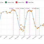
ALT The Crop Cycle Detection model analyzes changes in NDVI over time to identify individual growing seasons. In this example, the model detects three cropping cycles and estimates the start, peak, and end of each season. Orange points show the raw NDVI observations, while the blue line shows the processed, interpolated time series used by the model.

ALT The model divides a typical seasonal NDVI curve into five broad stages, from bare soil, planting, and emergence through rapid growth, peak maturity, senescence, and post-harvest conditions.


ALT Partners from diverse institutions gathered to formally establish ADAPT-Kenya. Following months of governance design, stakeholder alignment, and policy integration, ADAPT-Kenya is now positioned to deliver impact through crop monitoring, yield forecasting, insurance zone delineation, and disaster risk reduction.
ALT Partners from diverse institutions gathered to formally establish ADAPT-Kenya. Following months of governance design, stakeholder alignment, and policy integration, ADAPT-Kenya is now positioned to deliver impact through crop monitoring, yield forecasting, insurance zone delineation, and disaster risk reduction.


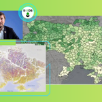
ALT The 2023 cultivation map shows how non-cultivated cropland was concentrated near the frontlines. The national map (A) is paired with examples from an area far from the front (B) and along the 2022–2023 frontline (C), where large areas of cropland were no longer being cultivated. At this mapping stage, fallow and abandoned fields were grouped together as non-cultivated cropland.

ALT This 2023 cultivation map shows how non-cultivated cropland was concentrated near the frontlines. The national map (A) is paired with examples from an area far from the front (B) and along the 2022–2023 frontline (C), where large areas of cropland were no longer being cultivated. At this mapping stage, fallow and abandoned fields were grouped together as non-cultivated cropland.

ALT Satellite images show how researchers distinguished cultivated, fallow, and abandoned cropland over the course of a growing season. Crop growth and harvest patterns identify actively cultivated fields, while signs of tillage can distinguish managed fallow land from abandoned fields with no visible farmer intervention. The red dots mark the locations being evaluated.


ALT This map, derived from NASA’s GEOS (Goddard Earth Observing System), shows an atmospheric river reaching Washington state in December 2025, during a winter marked by extreme rainfall and too little mountain snow. Source: NASA's Scientific Visualization Studio